
Around the valley of the small Maulne river

Around the valley of the small Maulne river
Medium
2h45
11,3km
+134m
-134m
Loop
Embed this item to access it offline
To see, to discover
- Val Joyeux Lake in Château-la-Vallière
- Rillé Lake
Attachment
- Downloadpdf
Topoguide FR-EN La Vallée de la Maulne
Description
- Marcilly-s/Maulne
It is underneath the porch of the Halle (covered market) on the Place de la Mairie in Marcilly-sur-Maulne that ramblers and families gather before setting out on this nice walk, a little over 11 kilometres in length, signposted with yellow markers. Right at the beginning, you go past the magnifi cent Saint-Saturnin church, built in the 12th century and extended in the 15th century by two south chapels and a larger northern one. The steeple is a tower crowned with a timber spire dating from the 15th century. - Washhouse
Walk down the « rue de l’Ecole », take « la rue des ponts » on your right (D 124) and you will see the old wash house, which has been restored, fed directly by the Maulne river, where the women did their washing in the 19th century. There are covered picnic tables that allow walkers to have something to eat in the shade. Next turn right after the bridge, then immediately left onto the sandy path. Carry on down this path. As you walk, you will have a wonderful view of the village of Braye-sur-Maulne. - Maulne Valley
You should then cross a public road that carries very little traffic. Next take the shady dirt track. At the top of the path, you will reach a tarred road (cul-de-sac) leading to a house. A few metres further on you will have a fi ne panoramic view of the Maulne valley that stretches out before you. - Fields and thickets
Next take the dirt path lined with vines, cornfi elds, wild copses and shrubs. Then, the landscape changes : as you walk down the pleasant dirt track, notice on your right the ÒbocageÓ, farmland criss-crossed. Go as far as the D 124 then continue down this road for about 150 metres. - Braye woods
Turn left after « La Maison Neuve » and follow the path, then the little tarred road, alongside the « Bois du Braye » farm (on your left). The term braye comes from the celtic word meaning damp land. Cross a public road and 200 metres after this, turn left towards « the Epopins ». 400 metres further on, you’ll see the Maulne valley again and a very beautiful tree that stands all alone on the landscape. Finally, turn right and go down the road for 150 metres or so. - Heritage vineyards
Take the left fork towards « La Vallée ». If you would like to shorten your ramble (variation marked with a dotted line on the map) follow the sign marked « PR Braye », otherwise continue straight ahead. Paths through the underwood and well-kept dirt tracks enhance your route. - Château de Marcilly
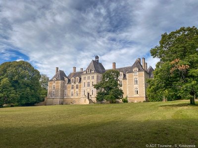
Cross a public road carrying little traffic, you can see once again the Maulne valley panorama and look down on the magnificent chateau de Marcilly, built by François Laval in the 15th century, extended with six corner pavilions by Charles Fouquet in 1608. This chateau owns a fine collection
of 15th century outbuildings, which were restored at the beginning of the 17th century. - Saint-Blaise
Go through a gate. The route next takes the paths running alongside fi elds of different crops as far as the « Morelière »
estate. Turn left and take the public road for 900 metres. At « Saint-Blaise », take the dirt track on the right that runs alongside cultivated fi elds. It is important to note that the clay soil has also contributed to the development of many orchards and apple trees. There are many livestock farms
and mixed farming dominates the region. - Boule de fort ball game
At the end of the track, turn left onto the departmental road towards Braye-sur-Maulne. If you wish, go and watch a game
of « Boules de Fort », a traditional local bowling game. - Braye-s/Maulne
To end this route with a flourish, walk up to the Saint-Pierre church in Braye-sur-Maulne the nave and belfry date from
the 19th century and the southern chapels from the 16th century. Go past the « randonnée » (hiking) signpost (situated
in a little square) and take the road to the right for about 250 metres then the path on your right to get back to Marcilly-sur-
Maulne, where you started (and end) your walk.
- Departure : Marcilly-sur-maulne, next to the city-hall
- Arrival : Marcilly-sur-maulne, next to the city-hall
Altimetric profile
Recommandations
Walking charter
- Cherish and respect nature.
- Listen to it, do not spoil it and do not harm it.
- Stay on the trail and be discreet.
- Do not damage plants or undergrowth.
- Do not smoke in the forest or do not light fires.
- Do not scare animals.
- Do not neglect human contact.
- Respect and get to know this rural world that welcomes you.
Information desks
16, pl. de l’église, 37140 Bourgueil
19, rue Thiers, 37130 Langeais
Access and parking
Parking :
City hall carpark
Report a problem or an error
If you have found an error on this page or if you have noticed any problems during your hike, please report them to us here: