
The Vienne and Loire rivers' confluence
Candes-Saint-Martin
The Vienne and Loire rivers' confluence
Very easy
1h
4,2km
+94m
-95m
Embed this item to access it offline
Description
- Departure
When you arrive in Candes-St-Martin (coming from Chinon), park your car in the car park on the left just before the ‘Bar-tabac-essence’. On leaving the car park, cross the road. If the Vienne is not too high, drive along it to reach the port of Candes. If not, follow the yellow signs through the narrow streets of the village. Then walk back up to the collegiate church, crossing the road again. - The Collegiate Church
Walk up the cobbled street to the right of the Collegiate Church. Walk behind this magnificent fortified church built in the 12th and 13th centuries on the site where Saint Martin died in November 397. Legend has it that when his body was brought back to Tours on a boat sailing up the Loire in glorious sunshine, the flora and fauna awoke: it was the first summer of Saint Martin. Next, drive past Château Vieux, an estate that became a castellany in the Middle Ages. Louis XI is said to have stayed here 18 times.
At the top of the road, turn right and stop in front of the Château Neuf (or new house), built in 1782 by Monseigneur Michel Amelot de Gournay. - Rue du Puits Saint-Michel
When you reach the square, turn right into Rue du Puits Saint-Michel and walk down to the left alongside the cemetery along a tarmac road framed by low walls made of tuffeau (a white stone typical of the Touraine region). You leave the village. Meadows and cultivated fields appear on either side. In front of you, the hillside is in Anjou... in the Pays de Loire region. - The Saint-Michel mill
Before turning left at the sign for La Bonnardière, look up on the right. You'll see the foundations of the Saint-Michel mill. As you go up the small tarmac path, you will notice old quarries used as sheds, dwellings or mushroom beds. At the top of the slope you come to a vast plateau bordered by vineyards (AOC Touraine appellation wines), orchards and cereal fields. - The forest of Fontevrault
Look out over the Fontevrault forest from the height of the orchard. Turn around to discover the moulin-cavier de la Tranchée (La Tranchée mill). At the top of a conical tower, this mill has a pivoting wooden cage known as a hucherolle, which supports the wings. - La Carroite
When you reach the hamlet of La Carroite, turn left and follow the track to the sign for Candes-Saint-Martin. Just before this sign, turn right at the iron cross and then left onto the dirt track. Opposite you are the ruins of the Moulin-tour, which you reach after crossing the crossroads. - The panorama
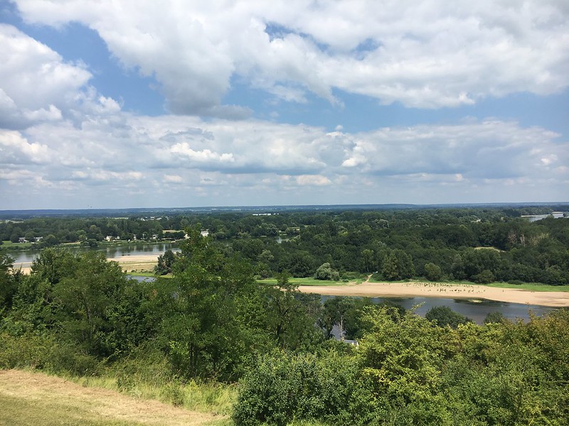
The panoramic view is exceptional. Near the mill is an orientation and landscape interpretation table, created by the Loire-Anjou-Touraine Regional Nature Park, showing the confluence of the Loire and Vienne rivers. On this table, you can also read the information panels on the fauna, flora, crops and vineyards.... On the lawn, everything is set out for a relaxing break or a lunch break while contemplating this beautiful landscape.
Follow the grassy path along the observation benches and go down the small stone path following the yellow markings entitled paved path to the Place du Puits. Turn right and walk down the paved path, continuing across the road to the collegiate church and the harbour. - The confluence
Admire the confluence: the Vienne flows into the Loire. The alluvial plain widens. The Val de Loire has been on UNESCO's World Heritage list since November 2000 as a living cultural landscape.
- Departure : Candes-Saint-Martin
- Arrival : Candes-Saint-Martin
- Towns crossed : Candes-Saint-Martin
Forecast
Altimetric profile
Information desks
4 Rue du Château, 37190 Azay-le-Rideau
1 Rue Rabelais,, 37500 Chinon
Place du Marché, 37120 Richelieu
Report a problem or an error
If you have found an error on this page or if you have noticed any problems during your hike, please report them to us here: